


Published on the 06/06/2013 | Written by Newsdesk
The world’s largest bulk commodity port is using geographical information system mapping technology to help build its future responsibly…
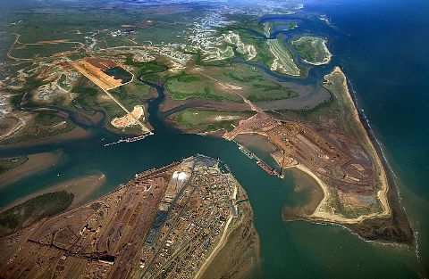
Western Australia’s Port Hedland Port Authority (PHPA), which shipped more than 246 million tonnes last year and won the 2012 ‘Austrlaian Port of the Year’ title, has used advanced GIS technology to develop an intelligent multi-layered mapping platform that provides a clear view of its existing and future infrastructure. The technology will help to support the port’s development, management and planning strategy over the next decade as it more than doubles its shipping weight by 2015 and beyond.
The technology itself visually represents PHPA’s core business information, such as the location of existing infrastructure, access routes, unused land and development plans, and other data, such as sites of cultural or environmental significance in one place, resulting in a comprehensive view of the port and its operations, which can then be used to guide decision-making in areas such as responsible land management.
Kevin Reece, GIS specialist and Esri Australia WA business manager said GIS technology would considerably aid and advance PHPA’s infrastructure development, especially in the current mining boom which makes it more important than ever for Australian ports to identify and implement GIS-driven strategies that will improve their operations and bottom-line.
“By accessing a geographic view of data, PHPA personnel can quickly visualise what is occurring and what is planned across the port,” said Reece. “With its map-based interface, the platform provides a ‘single point of truth’ that reduces the need to access or request data from multiple, competing technologies or specialised systems.
“The system not only enables PHPA employees to make more informed decisions; it also broadens the spectrum of users who are able to make those decisions – as the information is provided in the universally user-friendly format of a map,” added Reece.
He also said he believed that PHPA is leading the Australian port industry’s expansion of GIS technology across its operations.