


Published on the 13/09/2018 | Written by Jonathan Cotton
Australia has got big plans to harness the power of satellite tech. But first: how to handle the data deluge?…
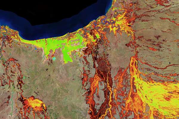
With the news in July that the government would commit almost AU$40 million of the federal budget to the Digital Earth Australia project – an attempt to create a publically available infrastructure that makes satellite imagery (and a wealth of overlaid data) available to all – Australia may just be on its way to creating a world-class satellite imagery archive that’s both interactive and useful.
It’s certainly an ambitious project: The group plans to make reliable positioning data – accurate to 10 centimetres in every corner of Australia (and accurate to three centimeters in areas with mobile coverage!) available in an easy-to-use format to both industry and government. (Currently, GPS generally can provide large parts of Australia with positioning accuracies of five to 10 metres).
Here’s how it works: Using the computing capabilities of the National Computational Infrastructure (NCI), Digital Earth Australia prepares the images for analysis by organising the vast volumes of satellite data into time-stamped ‘observations’, and removing ‘noise’ such as cloud cover, atmospheric conditions and shadows. That information can then be fed to government and industry to support productivity and innovation and the development of new digital products and services.
This, says the government, has huge potential for both business and industry as 30 years of satellite information in the Australian Government’s data archives is unlocked, formatted and made available.
And there’s a lot be gained: The Department of the Environment and Energy, for example, currently uses the platform to monitor water holdings, to help balance out how water across the continent is used for agriculture, communities and industry.
“Even though it is already providing a number of products to the Australian Government, we know that if we can get Digital Earth Australia into the hands of local business and industry, its potential could be almost unlimited,” says Digital Earth Australia program leader, Trent Kershaw.
It’s an exciting goal but not one without its challenges of course. As it turns out, wrangling all that data – and separating the wheat from the chaff – is hard. Just how can disparate data sets – literal petabytes of data from 30 years of satellite observation – be curated, formatted and liberated for public and private sector use?
“Even the simplest case of comparing two satellite images from the same spatial region over different seasons has historically involved a time-consuming process of retrieval and processing,” says an NCI spokesperson.
“However, the complexity scales exponentially when considering comparisons between regions of interest with different data sources altogether – requiring transformation of different coordinate projections as well as stitching together of data to address the whole region in a scientifically correct and seamless manner.”
There’s got to be a better way, and to that end the NCI has created a new program to make analysis and management of the wide range of file formats and data types that make up these earth observation datasets possible.
Known as GSKY, the program aims to combine an easy-to-use interface frontend (similar to Google Maps) with higher dimensional geospatial data. The result is a startling expansion on what is possible for satellite image tech – including real-time analysis.
“Previously, if researchers wanted to access our data they had to know where and how that data had been stored, hand-select the relevant files, and either come to NCI or have somewhere to download their data for their own analysis,” says Digital Earth Australia program director, Dr Trevor Dhu.
“GSKY has provided us with an easy way to get this data into the hands of a wide range of users and is the first step in truly unlocking the power of satellite data in Australia.”
Even if the requests encompass a large geographical area, NCI’s service can process queries in milliseconds – or virtually instantaneously, as far as the user is concerned.
And with the potential of machine learning and AI, the potential for Australia’s satellite data is only just beginning to be realised.
“Digital Earth Australia has been likened to a time machine that lets us look back through more than 30 years of information about the Australian environment to better understand the impact of decisions we make today,” says Kershaw.
“For example, with access to that wealth of information, farmers could use Earth observation data to make informed decisions about how to best manage their land, today and in the future.”
“Australia is leading the way with the Digital Earth Australia program, and together with the global Earth observation community we’re working to provide the proper connections between data and users.”
Try it yourself at http://gsky.nci.org.au/